|
A. 00 - 19
-EN- No precipitation, fog,(except for 11 and 12), duststorm, sandstorm, drifting or blowing snow at the station at the time of observation or, except
for 09 and 17, during the preceeding hour.
-GR- Όχι υετός, ομίχλη (εκτός περιπτώσεων 11 & 12), αμμοθύελλα, παρασυρόμενο χιόνι ή χιονοθύελλα στο σταθμό την στιγμή παρατήρησης,
εκτός από τις περιπτώσεις 09 & 17 που αφορούν στην τελευταία ώρα.
|
|
00
|

|
Cloud development not observed or observable (characteristic state of sky during the past hour).
Μη παρατηρούμενη ανάπτυξη νεφών.
|
|
01
|

|
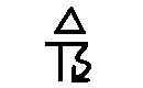
Clouds dissolving or becoming less developed (characteristic state of sky during the past hour).
Νέφη διαλυόμενα ή χάνοντας την ανάπτυξη τους.
|
|
02
|

|
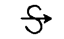
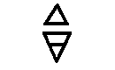
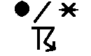
State of sky on the whole unchanged.
Κατάσταση ουρανού αμετάβλητος.
|
|
03
|

|
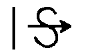
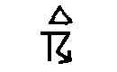
Κατάσταση ουρανού αμετάβλητος.
Νέφη γενικώς σχηματιζόμενα ή αναπτυσσόμενα.
|
|
04
|

|
Visibility reduced by smoke haze.
Ορατότης μειωμένη λόγω ομίχλης καπνού (αιθαλομίχλης).
|
|
05
|

|
Haze.
Ομίχλη - Περιορισμένη Ορατότητα.
|
|
06
|

|
Widespread dust in suspension in the air, not raised by wind at or near the station at the time of observation.
Διασκορπισμένη σκόνη στο αέρα, όχι από άνεμο στο σταθμό ή κοντά στο σταθμό παρατήρησης την ώρα παρατήρησης.
|
|
07
|

|
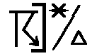
Dust or sand raised by the wind at or near the station at the time of the observation, but no well-developed dust whirl(s), and no sandstorm seen: or, in the case of ships, blowing spray at the station.
Σκόνη ή άμμος από άνεμο κοντά ή στον σταθμό, αλλά όχι καλόσχηματισμένοι αμμοστρόβιλοι ή παρατηρούμενη αμμοθύελλα.
|
|
08
|
|
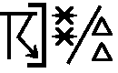
Well developed dust whirl(s) or sand whirl(s) seen at or near the station during the preceding hour or at the time of observation, but no duststorm or sandstorm.
Σχηματισμένοι σκονο-αμμοστρόβιλοι στον ή κοντά στον σταθμό την περασμένη ώρα, αλλά όχι σκονο-αμμοθέλλα.
|
|
09
|
|
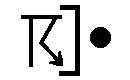
Duststorm or sandstorm within sight at the time of observation, or at the station during the preceding hour.
Σκονο-αμμοθύελλα ορατή από τον σταθμό την ώρα παρατήρησης ή την περασμένη ώρα.
|
|
10
|
|
Mist.
Ομίχλη – αχλή (άχλυς - αραιή ομίχλη, καταχνιά).
|
|
11
|

|
Patches of shallow fog or ice fog, less than 2m on land or 10m at sea.
Τμήματα ομίχλης (αραιής ή παγωμένης).
|
|
12
|

|
More or less continuous shallow fog or ice fog, less than 2m on land or 10m at sea.
Λίγοτερο περισσότερο συνεχής ομίχλη, λιγότερο από 2μ στην στεριά και 10μ στη θάλασσα.
|
|
13
|

|
Lightning visible, no thunder heard.
Αστραπή ορατή, όχι άκουσμα βροντής.
|
|
14
|

|
Precipitation within sight, not reaching the ground or surface of sea.
Υετός ορατός , που δεν φτάνει το έδαφος.
|
|
15
|

|
Precipitation within sight, reaching ground or the surface of the sea, but distant, i.e. estimated to be more than 5 km from the station.
Υετός ορατός, φτάνοντας το έδαφος, αλλά σε απόσταση από τον σταθμό μεγαλύτερη των 5χλμ.
|
|
16
|

|
Precipitation within sight, reaching the ground or the surface of the sea, near to, but not at the station.
Υετός ορατός, φτάνοντας το έδαφος, κοντά αλλά όχι στον σταθμό.
|
|
17
|
|
Thunderstorm, but no precipitation at the time of observation.
Καταιγίδα, αλλά όχι υετός την στιγμή της παρατήρησης.
|
|
18
|

|
Squalls (at or within sight of the station during the preceeding hour or at time of observation).
Γραμμή Λαίλαπας ορατή από τον σταθμό τώρα ή κατά την τελευταία ώρα.
|
|
19
|

|
Tunnel clouds or tuba (at or within sight of the station during the preceeding hour or at time of observation).
Σύννεφα σε σχηματισμό χωνιού/σιφώνες – υδροστρόβιλοι τώρα ή την τελευταία ώρα.
|
Top of page
|